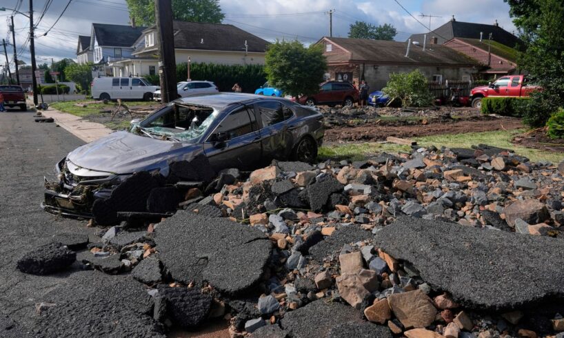
Debris, rubble and a damaged car lie on a street after flooding from rains in the area of North Plainfield, New Jersey, Tuesday, July 15, 2025. [AP Photo/Seth Wenig]
On Monday, a series of heavy rainstorms struck the US Northeast, unleashing flash flooding across New Jersey and New York City. At least two people lost their lives in Plainfield, New Jersey, when their vehicle was swept into a raging brook.
The deluge began Monday afternoon, as slow-moving thunderstorms tracked across the Mid-Atlantic, stalling over the New York–New Jersey metropolitan area. In northern New Jersey, rainfall totals ranged from 3 to as much as 6.5 inches (7.6 cm-16.5 cm) in a few hours, with the National Weather Service warning of rainfall rates peaking at 3–4 inches (7.6 cm-10.1 cm) per hour.
In New York City, Central Park received 2.64 inches (6.7 cm)—a record for July 14 dating back to 1908—while at one point 2.07 inches (5.26 cm) fell within a single hour. Heavy rain began in the afternoon and persisted well into the night. By midnight, much of the region was under continuing flash flood warnings, hampering any attempts at rescue or safe evacuation.
The physical impact was severe and widespread. Major highways, such as the Garden State Parkway, were submerged, leading to extended road closures. The New York City subway system flooded, with passengers trapped in waterlogged trains as water poured onto stairways and platforms.
Viral video footage from Monday night captured commuters desperately raising their legs as water surged through subway cars. Transit service was suspended across numerous lines. In Plainfield, New Jersey, entire streets buckled and sidewalks were splintered apart by the ferocity of the floodwaters.
Silt, debris and pieces of infrastructure were left piled high. Dozens of water rescues were conducted in Union County, New Jersey, with a house reported to have exploded in North Plainfield during the peak of the storm.
Tragically, two women lost their lives in Plainfield when their vehicle was swept by ferocious floodwaters into Cedar Brook. The brook, designed as a flood diversion channel, became a deadly torrent amid the storm. Witnesses reported seeing the vehicle being lifted and spun around by the rapid current before it disappeared downstream.
One bystander described hearing screams, including one victim crying out, “I don’t want to die” as a good Samaritan attempted a rescue. He was able to break a window, but the violent swell overwhelmed all efforts. Emergency responders, kept at bay by rising waters and dangerously low visibility, could not reach the vehicle until early Tuesday morning, when divers recovered both bodies.
Plainfield Mayor Adrian O. Mapp issued a statement mourning the loss:
All of Plainfield grieves this latest loss. To lose four residents in such a short span of time is unimaginable. We mourn with the families, and we remain committed to doing all we can to strengthen our emergency response systems and protect residents from future harms.
Two weeks earlier, on July 3 during a previous storm, a falling tree killed two other people in a car in Plainfield. Local and state officials have warned that the region is experiencing extreme weather at levels “like it has never experienced before.”
The disaster in New Jersey, followed by 10 days the unprecedented July 4 floods in Kerr County, Texas, which swept away entire neighborhoods and caused one of the deadliest weather events in the state’s modern history.
The Guadalupe River swelled from a gentle stream into a raging wall of water as torrential rain fell faster than any infrastructure could absorb. As of July 15, at least 130 people were confirmed dead in central Texas, with more than 107 of those fatalities occurring in Kerr County alone—including at least 37 children.
Nearly 100 people remain missing. Search and recovery efforts are ongoing, but officials caution that the full list of the dead may not be known for several more weeks. Many areas remain impassable, and some bodies may have been carried miles downstream or buried under silt and debris.
Search dogs, sonar equipment and drones are being used as officials race against incoming storms and severe heat that further hamper operations. “We are throwing every resource possible into Kerr County, but it’s heartbreakingly slow going,” stated a spokesperson from the Federal Emergency Management Agency (FEMA). “These won’t be fast recoveries.”
The link between these extreme weather events and man-made climate change is undeniable. Scientific consensus confirms that global warming allows the atmosphere to hold more moisture, directly fueling more intense rainfall and flash flood potential. “These are classic textbook examples,” said Dr. Lauren Zettel, a climate scientist at Columbia University.
Zettel went on, “Warmer air retains more moisture—so when a storm finally releases that moisture, you get explosive precipitation over a short period dominating local streams and drainage systems.”
A National Climate Assessment released earlier this year confirmed that the heaviest storms in the US South now produce 20 percent more rainfall than half a century ago. A study by ClimaMeter found that “meteorological conditions” like the July 4 Texas flooding have become “significantly more conducive to extreme precipitation due to increases in atmospheric moisture driven by global warming.”
The ClimaMeter report continues: “Natural variability alone cannot account for these changes. We are witnessing the impacts of anthropogenic climate change unfold in real time.”
The growing human toll from severe storms this year is staggering. So far in 2025, storms and flooding have claimed hundreds of lives and left entire communities destroyed.
Among the other most deadly events are:
Northern West Virginia was hit particularly hard on the night of June 14 through June 15, 2025. Between 2.5 and 4 inches (6.4 cm and 10.2 cm) of rain fell in less than an hour, overwhelming already saturated ground. Flash floods struck the cities of Wheeling, Triadelphia, Valley Grove and Fairmont and washed out roads, caused apartment building collapses and uprooted homes. At least seven people were killed, including a three-year-old child. Hundreds were rescued from cars, homes or trees; a state of emergency was declared across affected counties.Heavy rainfall and flash flooding in Central Texas occurred between June 10 and June 13, 2025, dropping 6 inches (15.2 cm) of rain within a very short period due to slow-moving convective storms and a surge of tropical moisture from the Gulf of Mexico. San Antonio and surrounding areas saw fast-paced floodwaters which resulted in the deaths of 13 people. First responders conducted over 70 water rescues with many victims caught in their vehicles or swept away while attempting to flee flooded areas.A powerful tornado outbreak struck the Midwest on May 16, 2025, causing extensive destruction, numerous casualties and widespread disruption. The outbreak was part of a larger severe weather pattern that began on May 15, which intensified and produced a total of 60 confirmed tornadoes across the Midwestern and Southeastern United States. The most severe impacts occurred in Missouri, Illinois, Kentucky and Arkansas. The most catastrophic event of the outbreak was a violent EF4 tornado that struck the cities of Somerset and London, Kentucky, resulting in 19 deaths—making it the deadliest tornado in Kentucky since 2021. In all, the outbreak resulted in 27 tornadic deaths, with an additional four non-tornadic fatalities (likely from related circumstances such as vehicular accidents and indirect storm impacts) and at least 168 injuries.A barrage of storms hit Mississippi, Alabama and Georgia between April 2 and April 7, 2025, resulting in deadly consequences for residents and destruction of infrastructure and entire communities. The storms were fueled by a slow-moving weather system and a stationary front that triggered both a widespread tornado outbreak and historic, life-threatening flash flooding across much of the region. By April 6, at least 18 river gauges registered major flooding, with forecasts warning that as many as 50 gauges could reach major flood levels across the Mid-South and Southeast in the following days. At least 24 people died and 47 were injured from the storms, which were part of a broader outbreak of tornadoes and historic flash flooding in the region. April 2025 became one of the most active and destructive months on record for tornadoes in the US, with a remarkable 299 twisters recorded nationally that month.The Rio Grande Valley in South Texas and northern Mexico had catastrophic flooding between March 26 and March 28, 2025, due to torrential rain unprecedented for the region and the time of year. Nearly 20 inches (50.8 cm)—and in some locations over 21 inches (53.3 cm)—of rain fell across eastern Starr County, southern Hidalgo County and northern Cameron County in Texas, crushing previous daily, multi-day and even March monthly rainfall records. This deluge rivaled historic tropical cyclone events in the region and produced a once-in-a-century or even once-in-a-200-year flooding scenario for much of the Rio Grande Valley. The consequences were widespread inundation, major road closures, massive flooding and displacement of the population. The storms claimed at least six lives in the Rio Grande Valley and cross-border regions. Reports confirmed at least three deaths in Hidalgo County, one fatality in Reynosa, and further direct and indirect fatalities during and after the event across Cameron and Willacy counties.A powerful and destructive storm system hit West Virginia, Kentucky and Tennessee from February 15 to February 16, 2025, and brought intense flash flooding and tornadoes across the region. The consequences were severe. At least 18 people died across the impacted states, and thousands were forced into emergency situations. The storm delivered relentless, torrential rainfall, with many areas receiving 5 to 7 inches (12.7 cm to 17.8 cm) of rain in a very short period. In Kentucky, every one of the state’s 120 counties was impacted by flooding, landslides or storm damage. Floodwaters quickly inundated hundreds of roads, washed away bridges and caused widespread power outages, forcing authorities to urge residents to stay off the roads and take refuge on higher ground. Swift-water rescue teams saved more than 1,000 people by Sunday afternoon, including emergency evacuations of two nursing homes, where over 100 patients were moved to safety. Louisville’s river patrol and fire departments worked together to rescue stranded residents as neighborhoods flooded.
Despite clear warnings, government officials have routinely deflected responsibility for the catastrophic failures in preparation and mitigation. Virtually nothing has been done over decades to combat climate change, and the Trump administration declares it a “fraud” and openly encourages fossil fuel production to increase the profits of big oil.
Federal Emergency Management Agency (FEMA) leaders have spun reduced public assistance and building support by insisting on “streamlined reform” and “private-sector involvement,” claiming previous federal efforts were “bloated.”
In Texas, Governor Greg Abbott insisted the state “has the tools we need” despite clear shortages in emergency personnel, equipment and infrastructure maintenance. Similarly, Homeland Security spokesperson Tricia McLaughlin dismissed FEMA’s delayed deployments after the Texas flood, saying, “The old model of federal overreach failed Americans repeatedly. State resilience is key.”
These dire floods have arrived after years of deliberate policy decisions to underfund storm preparedness. The 2025 federal budget included crippling cuts to the Building Resilient Infrastructure and Communities (BRIC) program and terminated the Flood Mitigation Assistance (FMA) program—together representing over $3 billion in forecast public flood defense.
At the same time, critical Agriculture Department soil and river management programs were cut by nearly 88 percent. In communities like Plainfield and Kerrville, these funds would have prevented deadly road collapses and strengthened drainage systems. As an engineer in Texas anonymously stated, “This didn’t have to happen. We had the blueprints. They just killed the funding.”
While life-saving systems are hollowed out, funding continues to pour into other areas of the federal budget with little scrutiny. Over $930 billion has been allocated to defense spending this fiscal year, along with billions more earmarked for Immigration and Customs Enforcement (ICE) operations, private immigrant detention centers, militarized police forces and corporate subsidies for surveillance systems.
The flash floods that ripped through Plainfield and New York, as well as the devastation in Kerr County, are not unpredictable or sporadic “natural” disasters. They are the tragically logical outcome of decades of policy decisions—bolstered by both capitalist parties—which put profit and militarism above people’s lives.
Sign up for the WSWS email newsletter