SINGAPORE – An artificial intelligence-powered underwater robot developed in Singapore is giving scientists a clear map of corals in the Republic’s murky waters.
The robot, created by a team from the Singapore University of Technology and Design (SUTD), can generate a low-resolution 3D digital twin of coral reefs within minutes, a process that would ordinarily take hours, said Assistant Professor Malika Meghjani, who leads the university’s Multi-Agent Robotics Vision and Learning Lab.
Not only can the lab’s underwater robot technology speed up the process of mapping corals, but it can also assess ship hulls and monitor the impact of oil spills, said Prof Meghjani at a media showcase on Sept 25 held by the International SeaKeepers Society Asia in the waters off Sentosa Cove, which brought together innovators tackling key marine challenges.
The map paves the way for marine biologists like Ms Sam Shu Qin to monitor the health of coral transplants at restoration sites and make quicker decisions about which areas to prioritise.
For Singapore’s coral gardeners, tracking the health of reefs is a manual task of painstakingly photographing individual corals and piecing together the footage in a lab, a job made more tedious by clouds of sediment.
“Sometimes, it’s so bad that all you can see is just a few centimetres in front of your face,” said Ms Sam, who tends to the coral garden at Sentosa Cove, an initiative co-funded by the International SeaKeepers Society Asia, which promotes ocean research, conservation and education with the yachting community.
Equipped with a system called Maplion, Prof Meghjani’s robot helps operators capture visual information on corals and any other underwater structures, highlighting any gaps the operators have missed in order to generate a comprehensive 3D map.
“It is a very useful tool if we can successfully map coral transplants and monitor their growth over time at coral restoration sites, or even reef surveys during harmful events like coral bleaching and oil spills in Singapore’s highly sedimented waters,” said Ms Sam, a lecturer at NUS College and co-founder of the non-profit Our Singapore Reefs.
The AI-powered robot frees scientists to focus on analysis and restoration work, instead of spending hours photographing corals.
In the future, the 3D maps can also be used to train children to identify corals and marine life without having to dive into the waters, Ms Sam added.
The maps can support efforts like the National Parks Board’s initiative to plant
100,000 corals,
with the SUTD team hoping to help monitor sites like those in Sisters’ Islands Marine Park.
The team is optimising the robot to navigate shallow and rocky coral reefs, as well as the notoriously strong currents of Singapore’s first marine park.
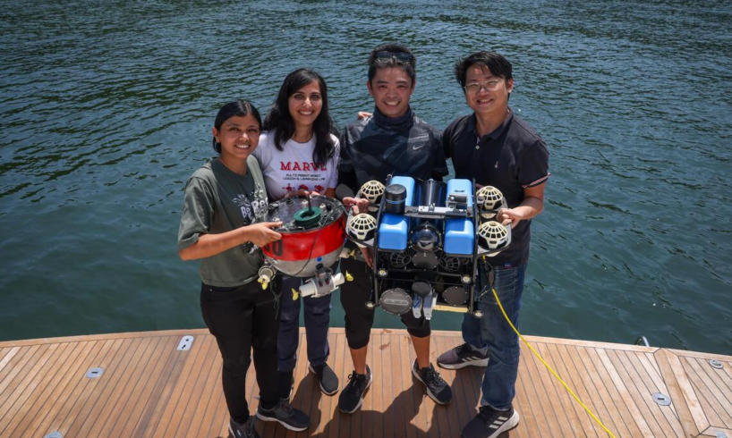
In addition to its role in conservation, the robot, weighing about 20kg and capable of diving to depths of up to 30m, will also help assess ship hulls and other underwater structures like pipelines.
Assistant Professor Malika Meghjani operating the underwater robot on Sept 25.
ST PHOTO: JASON QUAH
By generating a standardised 3D report on biofouling – the accumulation of marine organisms on a ship’s hull – it can provide a “proof of stamp” that a vessel has been cleaned, preventing disputes, said Prof Meghjani.
On Sept 25, the robot’s capabilities were demonstrated aboard the Discovery Yacht Legend. The vessel, part of the society’s fleet, is being used by the team for an 18-month project with A*Star and funded by the National Robotics Programme, which aims to use the technology for hull assessments.
Further discussions are also under way with the Maritime and Port Authority of Singapore and the Singapore Maritime Institute to deploy robots as first responders during oil spills, where they would be capable of detecting chemical changes, she added.
The robot, weighing about 20kg, is capable of diving to depths of up to 30m.
ST PHOTO: JASON QUAH
At the media preview, Mr Luc des Vallieres of international non-profit Plastic Odyssey, also launched a decade-long mission with Unesco to study and eliminate plastic pollution at marine world heritage sites.
While these marine sanctuaries cover less than 0.5 per cent of the ocean’s surface, they shelter 15 per cent of the world’s marine biodiversity and house 21 per cent of the ocean and coastal ecosystems that capture planet-warming carbon.
The mission builds on the success of an expedition that cleaned up the uninhabited Henderson Island in the Pacific Ocean, which was once named the place with the world’s highest density of plastic waste.
A buoy operated by Prof Malika Meghjani’s team.
ST PHOTO: JASON QUAH
With the aid of a raft, parasail and the non-profit’s plastic recycling vessel, the group removed 9 tonnes of debris from the remote Unesco-protected coral atoll.
The plastic was then recycled and transformed into street furniture for Pitcairn Island, located some 190km away.
Revealing plans to build another ship that can act as a plastic waste processor, Mr des Vallieres said: “The idea is to have this kind of platform to collect, transport and treat on board some waste, which can be replicable for small islands or very remote places where it doesn’t make sense to have a factory.”
Of the 51 Unesco sites, 10 are in Asia. They include Indonesia’s Komodo National Park and the Philippines’ Tubbataha Reefs Natural Park.
Mr des Vallieres, who leads Plastic Odyssey’s Asia team, estimated that running the expeditions will require about US$3 million (S$3.9 million) of funding annually, a funding gap that the organisation is still looking to fill.
Such solutions to protect oceans and coastal communities across the Asia-Pacific will be discussed at The Ocean Collective Summit on Oct 2 and Oct 3 at Sheraton Towers Singapore.