KISUMU, Kenya Oct 12 – The County Government of Kisumu has partnered with the United Nations Development Programme (UNDP) to roll out a drone-based risk mapping initiative.
This forms part of the broader “Strengthening Urban Resilience to Emerging Disaster and Climate Risks” project, which is funded by the governments of Denmark and South Korea.
The initiative, running until March 2026, targets cities facing high disaster risk, particularly those vulnerable to floods, heatwaves, environmental degradation, and conflict.
Kisumu, prone to frequent flooding and rapid urban expansion, stands to benefit significantly from the program.
As part of the project, the County’s Emergency Operation Centre (EOC) is being equipped with advanced tools for real-time risk analysis and disaster response.
These include flood-mapping drones and 3D modelling software designed to enhance monitoring of flood-prone areas, assess other potential hazards, and support timely, data-driven decision-making.
The drone technology will also enable high-resolution mapping of critical infrastructure and vulnerable settlements, supporting risk-informed urban planning and sustainable development strategies.
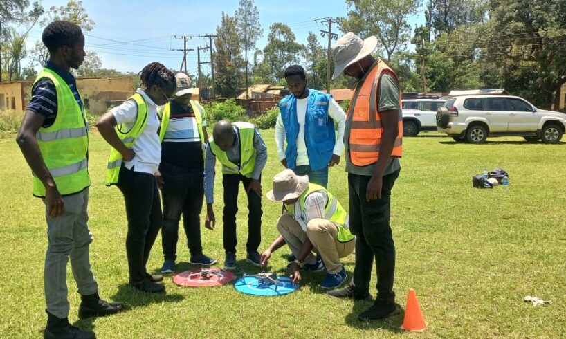
Already, five technical officers from the county government have undergone professional training and earned their Remote Pilot Licences (RPLs), in compliance with regulations from the Kenya Civil Aviation Authority (KCAA).
The training was conducted by Drone Space, a KCAA-accredited institution, and included both classroom instruction and practical on-site sessions.
The officers, selected for their roles in disaster management, urban planning, and resilience-building,will form Kisumu’s first in-house drone mapping and risk analysis team.
They will be responsible for continuous data collection, risk monitoring, and geospatial analysis, embedding resilience efforts within the county’s technical systems.
“The integration of drone technology into our disaster management framework marks a turning point for Kisumu,” said Salmon Orimba, the County Executive Committee Member in charge of Disaster Risk Management.
Orimba said for the first time, the county government of Kisumu will have real-time visibility of risk-prone areas, enabling faster, evidence-based responses.
“This initiative strengthens our ability to protect communities and ensures resilience is built into every aspect of our city’s growth,” he said.
UNDP Disaster Risk Reduction and Resilience Specialist Raphael Mutitu noted that the collaboration with Kisumu County reflects a commitment to ensuring innovation and technology to serve people at the local level.
“By investing in tools, data, and capacity, we are building a foundation for sustained resilience,” he said.
The project aligns with Kisumu Governor Anyang’ Nyong’o’s vision of transforming Kisumu into a disaster-resilient county.
Last year, the Governor signed on to the Making Cities Resilient 2030 (MCR2030) global initiative led by the United Nations Office for Disaster Risk Reduction (UNDRR), reaffirming the county’s commitment to risk-informed development.
The introduction of drone mapping into Kenya’s urban resilience landscape marks a significant milestone.
Kisumu’s efforts demonstrate how digital innovation, strategic partnerships, and local capacity-building can safeguard lives, protect infrastructure, and pave the way for a climate-smart, resilient urban future.