A dangerous storm has lashed Brisbane and other parts of south-east Queensland with hail, rain, wind and lightning.
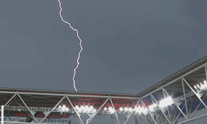
The wild weather took out power for tens of thousands today and the Pacific Championships at Suncorp Stadium were suspended over lightning fears.
The Darling Downs, Toowoomba and Ipswich were all in the firing line as yards were turned upside down and streets strewn with debris.
The Pacific Championships was suspended as Brisbane was hit by storms. (Nine)
Melbourne was lashed by wild weather that caused flash flooding across the city and suburbs.
A tram was stuck in Richmond and some cars were stranded by sudden flash flooding in both South Melbourne and West Melbourne.
The high risk of thunderstorms prompted the state’s Chief Health Officer to issue an epidemic thunderstorm asthma forecast warning of “high” for the northern country district.
“Epidemic thunderstorm asthma is where a large number of people suddenly develop asthma symptoms over a short period of time and is thought to be triggered by a unique combination of high pollen levels and a certain type of thunderstorm,” the Chief Health Officer’s office said.
“The Bureau of Meteorology works closely with the department to forecast the risk of an epidemic thunderstorm asthma event.”
A total fire ban will be enforced from midnight tomorrow for large parts of south-east Queensland ahead of a double forecast of “dangerous” storms and sweltering heat.
The ban, which will be in effect for 24 hours, will apply from Noosa stretching down to the Gold Coast and includes the Scenic Rim and Somerset regions.
The Queensland Fire Department confirmed the fire ban will remain in place until midnight on Tuesday due to heightened fire conditions.
A total fire ban for south-east Queensland will be in place from midnight on Monday. (Queensland Fire Department)
Unusually hot weather is sweeping across the state, made worse by potential thunderstorms which could whip up some dangerous fire conditions.
“With hot, dry and gusty westerly winds ramping up, large parts of Queensland will see heightened fire danger today,” the Queensland Fire Department warned in a message to residents.
“QFD crews are prepared to respond, but we need Queenslanders to be mindful of the very real risk this weather poses.
“Avoid any activities that could create a spark, as any fires that start in these conditions could become dangerous very quickly.”
A storm in the Brisbane suburb of Mount Coot-tha. (9News)
Storms forecast for state’s south-east
Thunderstorms remain a possibility next week in Queensland as the cooler change arrives.
Storm and showers are still forecast across much of the state tomorrow, with severe storms are possible across parts of the central and south-east coast.
Residents in Brisbane and the Gold Coast may avoid the worst of it.
Sizzling heat still lingering
A heatwave warning has also been issued by the Bureau of Meteorology for central, north and north-west Queensland.
Maximum temperatures could nudge the mid-40s in some regions, including the Central Highlands and Coalfields, Northern Goldfields and Upper Flinders, Central West, North West and Gulf Country districts.
Unusually hot weather is sweeping across the state, made worse by potential thunderstorms which could whip up some dangerous fire conditions. (9News)
The severe heatwave conditions will begin to ease early next week as a cooler burst arrives.
Temperatures are forecast to drop in the south from Monday, and across central Queensland from Tuesday as the cold front moves away from the coast.
Northern parts of the Northern Territory and Western Australia will see little relief from the heat this week, the BoM warned.