Drivers urged to avoid city centre until after 9.30am on Tuesday
15:53, 08 Dec 2025Updated 16:58, 08 Dec 2025
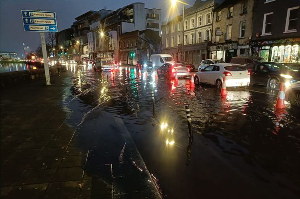
Flooding on Lavitt’s Quay
Crews are being deployed across Cork city and county this afternoon as Ireland prepares for gale-force winds and flooding during Storm Bram.
Our second named storm of the season will make its presence known all around the country from tonight onwards. A range of weather alerts will come into effect over the next 24 hours, including a Yellow Wind Warning for Ireland and Orange Alerts for most of Munster and the West coast. Both City and County Council crews are currently preparing for the worst on Tuesday, as a ‘severe weather and flood warning’ has just been issued for Leeside.
A spokesperson for Cork City Council says they have been working with Met Éireann for the past 24 hours to discuss the potential impacts of Storm Bram. Commuters are warned that a number of road closures and traffic restrictions on the city quays (e.g. Wandesford Quay, Lavitt’s Quay and South Terrace) will be necessary around high tide at approximately 8.30am tomorrow.
Diversions will be put in place, but widespread delays are still expected. Restrictions will be introduced from early morning to reduce the impact of traffic moving through standing water. The public is urged to avoid travelling into the city centre until after 9.30am.
Content cannot be displayed without consent
Homeowners and businesses that are normally affected by city flooding should take precautionary measures to protect their properties. Areas prone to flooding include:
Morrison’s QuayFather Mathew QuayFather Mathew StreetUnion QuayTrinity BridgeSouth TerraceRutland StreetSawmill StreetLavitt’s QuayKyrl’s StreetKyrl’s QuayCrosses’ GreenSharman Crawford StWandesford Quay
The public should avoid parking in these areas until after 9.30am. The City Council’s Customer Service Unit (CSU) will operate from 9am on Tuesday morning, to allow members of the public to contact them with any issue caused by the severe weather event. The CSU can be contacted on 021-4924000.
Cork City Council’s out-of-hours contact number will be available overnight on 021-4966512 for non-emergency reports like blocked gullies, trees down in public parks, etc. All emergency situations should be reported directly to the emergency services on 999 or 112.
A spokesperson for Cork City Council added: “In addition to the orange wind warning, the significant storm system is likely to generate a high level of storm surge at high time on Tuesday morning, and combined with the forecasted heavy rainfall and significant winds, Cork City Council is warning of flooding on low-lying quays at high tide tomorrow morning. Cork City Council will post regular updates to our social media accounts as well as to the City Council’s website (www.corkcity.ie)”
Meanwhile, Cork County Council’s Severe Weather assessment team also met today and is currently rolling out pumps and sandbags in towns and other areas prone to flooding. A spokesperson has advised that “after a week of persistent rain, many rivers are approaching bank full conditions with heavy rain falling on already saturated ground.”
Commuters across the county are being warned of hazardous travel conditions tomorrow, with fallen trees expected to cause major traffic disruptions. Issues such as these should be reported to your local Council office during working hours or via the Council’s Emergency number on 0214800048, which will remain in place out-of-hours.
CorkBeo will have regular updates today and through tomorrow’s Orange Alert.
Met Éireann has issued – and later updated – a large number of weather warnings today. At time of writing, the latest alerts are for:
Orange Wind Warning – Cork, Kerry, Waterford, Wexford. From 7am – 3pm on TuesdayOrange Wind Warning – Clare, Limerick, Donegal, Galway, Leitrim, Mayo, Sligo. From 10am – 9pm on TuesdayYellow Rain Warning – Carlow, Kilkenny, Wexford, Cork, Kerry, Tipperary, Waterford. From 9pm Monday – 9am on TuesdayYellow Wind Warning – Ireland. From 6am – 9pm on Tuesday
The following advice has also been issued:
Monitor Met Éireann forecasts over the next 24 hrs – conditions may change quickly. Visit https://www.met.ie/ for the most up to date information. Information is also available across the Met Éireann App, social media platforms (@meteireann) and other news media sourcesCheck Cork County Council’s website and social media channels for information on road closures, flooding updates, and community alertsAllow for disruption during Tuesday morning commutePlan extra travel time and reduce speedExpect surface water, debris and poor visibility on Tuesday morningCheck in with neighbours, older people or anyone who may need assistance in case conditions worsenBe aware of elevated flood risk and high windsTake care on exposed roads and bridgesWatch for fallen branches and debrisESB Networks is highlighting the dangers posed by fallen live wires and is advising the public and the emergency services to stay away from these fallen cables and to report such cases to it immediately. ESB Emergency Services can be contacted at 1800 372 999. The public can monitor www.PowerCheck.ie in regards to power restoration times.Uisce Éireann customers can check the website and social media channels for updates and to get in touch with any issues or concerns via their 24/7 customer care centre at 1800 278 278Stay back from riverbanks, streams and canals – water levels may rise quicklyKeep children and pets away from waterways and flooded areasDo not drive through floodwater – turn back and use another routeCoastal areas may experience wave overtopping, storm surge, and tidal flooding, especially in low-lying locationsKeep away from coastal edges, harbours, piers and low-lying promenades during high tideThe Irish Coast Guard advice remains: “Stay Back, Stay High, Stay Dry”
Source