The 600-mile wall of cold air and snow showers could spread
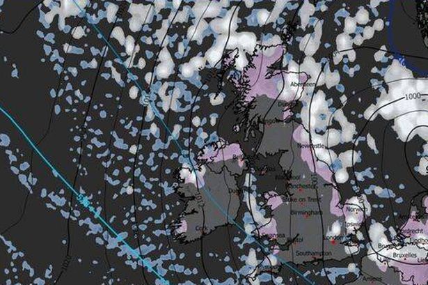
The New Years Day snow cloud stretches some 600 miles from the east coast of northern Scotland to southern England(Image: WXCharts)
Ireland and the UK could be bracing for a dramatic return to harsh winter conditions as fresh weather charts expose a colossal 600-mile barrier of frigid air and snow showers sweeping across the nation at the beginning of 2026.
Met4Cast has predicted that snow could still follow heading into early January with the Beast From The East set to hit 24 counties in the UK according to forecasters.
Posting on X, they said: “Modelling has trended more favourably to a blocked and likely protracted cold spell of weather through the Christmas period and into early January.
Fundraiser launched following tragic fire damage to Irish train stationSocial welfare 2026 Child Benefit dates including bank holiday changes
“Colder weather is on the way and I suspect, potentially, some snow.”
Alan O’Reilly of Carlow Weather has said that there will be a big change in weather patterns heading into Christmas Day, making it colder than this week.
He said: “Most of Europe is warmer than average today but by Christmas Day many areas will be cooler than average as we see a big change in our weather patterns that will finally give us a break from the wind and rain here.”
Meanwhile, Met Eireann’s latest forecast indicates huge drops in temperature at night time.
The most recent WXCharts projections for the New Year, compiled on December 21, indicate a textbook “Beast from the East” pattern emerging, with icy air masses from continental Europe advancing westward over the North Sea and delivering snowfall to eastern, northern and even central regions of Britain.
A huge snow bomb is predicted to hit large parts of Ireland and the UK(Image: Getty)
One WXCharts weather chart, offering a ‘Winter Overview’ for January 1, reveals the snow cloud stretching nearly the full extent of the UK, covering approximately 600 miles from Scotland’s eastern coastline down to England’s southern counties, whilst penetrating 300 to 350 miles inland.
This positions vast swathes of territory squarely in the path of snow showers, treacherous icy conditions and nighttime temperatures dropping below zero.
Concurrently, temperature charts also applicable for January 1 demonstrate extensive overnight lows tumbling beneath 0C, especially across inland areas, with regions of Scotland and northern England experiencing temperatures significantly below freezing point. Daytime temperatures are forecasted to barely rise above freezing, particularly in areas where snowfall is expected.
The chart suggests that by midday on New Year’s Day, central Scotland and the vicinity of Newcastle could still be experiencing a chilly -5C, while Birmingham and its surroundings will likely see temperatures around -2C.
For all the latest breaking news headlines today, visit our website home page.
Even London and much of southern England may remain below freezing, with Kent and Hampshire potentially seeing lows of -2C.
By noon on the first day of January, the warmest spots in the UK are predicted to be Devon and Cornwall, the southwestern coast of Wales, Stoke-on-Trent, and coastal regions of Northern Ireland, including near Belfast, where temperatures might just edge above freezing to reach 4C near the coastline.
Snow depth forecasts suggest a widespread coverage of 2-6cm, with 8-14cm possible over higher ground in northern England and Scotland.
Areas close to Norwich and Ipswich could even see up to 4cm of snow blanketing the ground by 6pm on January 1.
Outside of Scotland, Middlesbrough is anticipated to experience the deepest snowfall in England, with up to 5cm, as per WXCharts.
Some 8-14cm of snow is possible over higher ground in northern England and Scotland on January 1(Image: WXCharts)
Whilst WXCharts’ weather maps forecast snow for January 1, it’s important to note that the Met Office’s long-range outlook for this timeframe doesn’t yet indicate any snowfall, though it does suggest chilly conditions ahead.
The Met Office’s forecast for December 25 through to January 3 states: “Continued mostly settled conditions expected, as high pressure builds to the north of the UK.
This will bring a strengthening easterly then northeasterly wind over the period, with wind-chill making it feel colder.
“Whilst there will be a fair amount of dry weather, a few showers will still be possible, particularly across eastern and southern parts which may be wintry in places, more especially over high ground. High pressure will likely dominate the weather in the run up to the New Year, slowly drifting to the west.
“This will maintain largely settled conditions, although with an increasing chance of showery conditions later in the period.
“Temperatures will be below average much of the time, with frost likely where clear skies and light winds prevail.”
Concerning extended weather predictions, the Met Office cautions: “When looking at forecasts beyond five days into the future the chaotic nature of the atmosphere begins to play a larger part – small events currently over the Atlantic can have potentially significant impacts on our weather in the UK and Ireland in several days time”.
Galway Beo’s top stories and breaking news service on WhatsApp.
Click this link to receive breaking news and the latest headlines direct to your phone.
We also treat our community members to special offers, promotions, and adverts from us and our partners.
If you don’t like our community, you can check out any time you like.
If you’re curious, you can read our Privacy Notice.