
After violent storms, Brazil faces ongoing cyclone threat — severe weather also forecast in Argentina
Thursday, November 13th 2025 – 10:55 UTC
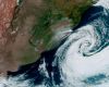
A cyclone is a vast area of low atmospheric pressure that can span thousands of kilometers
Following a powerful extratropical cyclone that swept across south-central Brazil last week —bringing heavy storms and a tornado that devastated parts of Paraná and Santa Catarina— meteorologists are warning that the country faces a continued risk of similar weather events through the end of the year.
Experts emphasized that while a precise forecast of the number of remaining cyclones is impossible, the passage of cold fronts in November makes new episodes likely. Meteorologists explain that the exact path and intensity of an extratropical cyclone can only be predicted days before it makes landfall.
Wanderson Luiz Silva, a professor of meteorology at the Federal University of Rio de Janeiro (UFRJ), noted that every extratropical cyclone is associated with a cold front. With more frontal systems forecast to pass through Brazil before the end of November, further cyclones are possible. It is necessary to monitor day by day to predict the location of the displacement of these cyclones, whether they will be closer to the Brazilian coast or further away, Silva told Metrópoles.
Antonio Marengo, a meteorologist at the National Center for Monitoring and Alerts of Natural Disasters (Cemaden), confirmed that one cyclone has already occurred and another is entering the region, reinforcing that accurate forecasts are only possible in the short term.
According to the National Institute of Meteorology (Inmet), a cyclone is a vast area of low atmospheric pressure that can span thousands of kilometers. In the Southern Hemisphere, winds rotate clockwise toward the center of low pressure, concentrating warm, humid air that rises to form intense clouds, leading to strong winds and heavy rain.
Marengo explained that extratropical cyclones are common in the South Atlantic. The danger arises when a cyclone intensifies and approaches the continent too closely, which can generate strong gales, hailstorms, and sometimes spawn smaller vortices that lead to tornadoes.
Cemaden meteorologist Marcelo Seluchi added that numerous scientific articles suggest cyclones are becoming more intense overall, a factor directly linked to climate change. Seluchi explained the physical process: more intense cyclones require greater moisture content supplied by a higher temperature in oceans and the atmosphere. You have an additional source, which are the warmer oceans, and an atmosphere that can retain that moisture. So, that is the recipe. It is one of the requirements for having more intense cyclones, he commented.
Argentina
Meanwhile, in Argentina, heat is expected to return to the Buenos Aires area before storms next weekend. After a brief spell of minor rainfall from a weak cold front, warm, sunny weather is set to return to the Buenos Aires Metropolitan Area (AMBA) before a predicted round of instability brings thunderstorms by the weekend, according to the National Meteorological Service (SMN), which forecasts clear skies and rising temperatures through Friday, driven by northeasterly winds. The weather will be warm and stable throughout the region.
Saturday will mark a significant temperature increase, with highs potentially hitting 32 °C. However, a new humid front is expected to move in, bringing the likelihood of rain and storms toward the night, which are predicted to last into the early hours of Sunday.
The SMN has also issued various weather alerts for other areas in Argentina, with the northern part of the country under Yellow and Orange Alerts for intense thunderstorms and strong winds, while Southern Argentina (southern Chubut and Santa Cruz) is under a Yellow Alert for strong winds. Westerly winds are forecast to reach speeds of 50 to 60 km/h, with gusts potentially hitting 90 km/h.