Darwin’s airport and supermarkets have closed as severe Tropical Cyclone Fina barrels towards land, having intensified into a category three system – the first cyclone of that strength in Australian waters in November in 20 years.
Darwin was expected to see the worst of Fina on Saturday evening, as the system advanced through the Van Diemen Gulf. It would be closest to the city at about 9pm, with sustained winds near the centre of up to 140km/hr and gusts up to 185km/h.
Incident controller, superintendent Kirsten Engels from NT Police, said the situation was serious, but there was no need to panic.
“We need people to go home. We need them to stop walking around the Nightcliff foreshore. No sightseeing, no joy rides. We need them to get home now.
“They must understand that what we are in danger of is gusts of wind, debris. It’s time to go home.”
The BoM’s latest cyclone tracking map, which shows Severe Tropical Cyclone Fina is getting closer to Darwin. Illustration: Bureau of Meteorology, Australia
Engels advised residents that the standard emergency warning siren, or the SEWS, would played on radio, TV or social media ahead of important public safety announcements.
“Everybody should now be activating their household emergency plans, staying put and avoiding unnecessary travel.”
Darwin airport was closed on Saturday morning, with several airlines cancelling flights.
Darwin’s CBD was empty on Saturday as residents were urged to go home and enact emergency plans. Photograph: (A)manda Parkinson/The GuardianWaramungu painters Fabian Brown and Silas Morton head to the Civic Centre shelter ahead of severe Tropical Cyclone Fina moving through Darwin. Photograph: (A)manda Parkinson/The Guardian
The NT chief minister, Lia Finocchiaro, told the ABC additional police had been sent to remote communities and evacuation shelters had been opened.
“People can sustain themselves and their families for 72 hours with clean water, food, blankets, torches, whatever you might need.”
Finocchiaro said she had filled every water vessel in her home, recommending others do the same.
The Australian defence force was on standby to assist if requested by the Northern Territory government, according to MP Luke Gosling, the special envoy for defence, veterans affairs and northern Australia.
An approaching cyclone sparked a rush on bottled water at supermarkets in Darwin on Wednesday. Photograph: Lloyd Jones/AAPColes advised it would be closed on Saturday ahead of Cyclone Fina making landfall in Darwin. Photograph: Lloyd Jones/AAP
Speaking in South Africa, Anthony Albanese urged people in the cyclone’s path to look after themselves and others.
“My thoughts are with people at this time and also with the emergency service workers and others who will be working hard,” the prime minister said.
Northern Territory Emergency Service issued an emergency warning for Darwin to Cape Hotham, including parts of the Tiwi Islands around Wurrumiyanga, advising households to “take shelter now”.
A cyclone watch and act alert for other affected areas including parts of the Tiwi Islands including Pirlangimpi and Milikapiti, Daly River Mouth to Cape Don, and inland to Batchelor.
Shelves were empty in some stores across Darwin as the city prepared for the wild weather, while NT Emergency Service advised major supermarkets would be closed, and buses would not be running.
Phuong Le, from Woolner in Darwin, told Guardian Australia she and her housemates had filled jugs, the kettle and even the bathtub with water.
Le, who experienced 2018’s Cyclone Marcus, said she had gone to several shops to buy gas bottles, toilet paper and enough canned food “for a couple of days, maximum a week”, with many shelves empty.
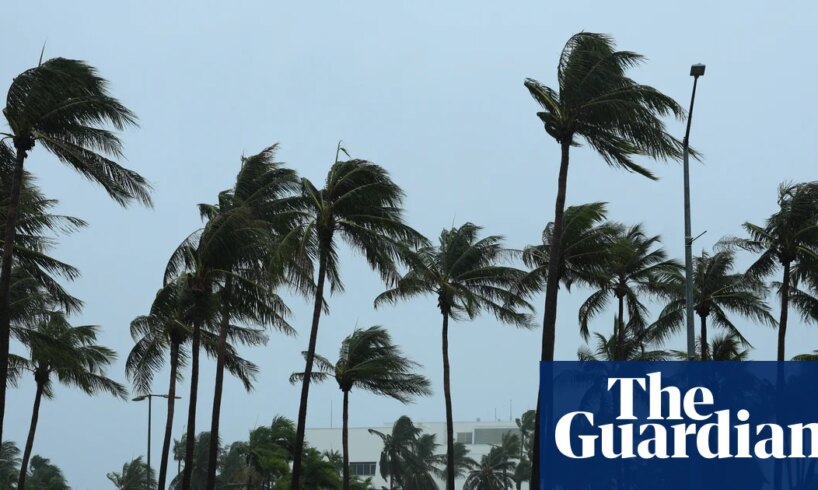
People watch Severe Tropical Cyclone Fina roll in at Nightcliff jetty, just outside Darwin CBD. Photograph: (A)manda Parkinson/The Guardian
Darwin radar shows Fina close to the southeast coast of Melville Island.
Pirrawayingi Puruntatameri, a Tiwi elder who lives on the northern tip of Melville Island, said he was concerned for friends in Darwin and in the south of Bathurst Island.
“People that I know in town actually called me to see if I was OK and prepared. I said: ‘I’m OK, I think I’ll be more worried about your mob because it’s heading your way in Darwin’.”
skip past newsletter promotion
Sign up to Breaking News Australia
Get the most important news as it breaks
Privacy Notice: Newsletters may contain information about charities, online ads, and content funded by outside parties. If you do not have an account, we will create a guest account for you on theguardian.com to send you this newsletter. You can complete full registration at any time. For more information about how we use your data see our Privacy Policy. We use Google reCaptcha to protect our website and the Google Privacy Policy and Terms of Service apply.
after newsletter promotion
Royal Darwin hospital has issued a code brown, a nationally recognised emergency alert which streamlines emergency management systems.
A spokesperson for NT Health said local emergency response plans were in place across all regions to ensure essential health services continued safely and that hospitals and health facilities in the Top End remained fully operational.
Severe Tropical Cyclone Fina was about 65km to the north-east of Darwin on Saturday afternoon .
Cyclone Fina rolls in at Nightcliff beach. Photograph: (A)manda Parkinson/The Guardian
The system was moving southwest at about 9km/h, said senior meteorologist Dean Narramore, from the Bureau of Meteorology, , with destructive winds, torrential rain, dangerous flooding, waves and storm tide, and possible disruption to essential supplies like electricity, water and gas.
Sign up: AU Breaking News email
Narramore said conditions had started to intensify around the core of the cyclone, with winds up to 185km/h. “That’s the inner eye wall, that circle you can see on radar where there’s not rainfall, and the rain’s circulating around that.”
As a category three system, there were sustained winds of 140km/h with “very destructive wind gusts” up to about 195km/h, according to the latest track map (issued at 12:41pm).
Heavy rain has already been falling across the NT, with 172.8mm recorded at Point Stuart since midnight.The bulk of the rain was still to come, according to the BoM.
The BoM issued a flood watch for parts of the north-west coastal rivers and Bonaparte coastal rivers, with significant rises expected.
Steven Pitkin, of Original Adelaide River Jumping Crocodile Cruises, said the cyclone had coincided with the movement of crocodiles at the start of the breeding season, which sees them seek nests in previously dry areas “as soon as the fresh water hits”.
He said the heavy rain was causing crocodiles to leave rivers and “go exploring”.
“If I went up the river with a bucket of food now, there might not be a single one there.”
Photograph: (A)manda Parkinson/The Guardian
High tide in Darwin was expected around 8pm, Narramore said, which would coincide with the worst conditions of the cyclone, particularly for coastal areas – expected to peak from about 5pm to 10pm.
“In the coming days, we’re likely to see a continuous Category 3 status through Sunday and Monday as it heads towards the northern Kimberley coast,” Narramore said.
The last cyclone to reach category three in November was tropical cyclone Bertie-Alvin in 2005, according to Weatherzone. Fina was also the equal earliest tropical cyclone to make landfall, as it briefly crossed the Cobourg Peninsula on Friday night before moving back over the ocean.
– with AAP