Northwest B.C. is home to epic rivers, big mountains, a rugged coastline — and relatively few people. Its diverse ecosystems are inextricably intertwined with the cultures of the Indigenous Peoples who have lived here and stewarded the lands and waters for thousands of years, and continue to do so today.
The staggeringly beautiful landscapes and rich cultures were what first caught my attention two decades ago — but it was the unpretentiousness of its communities that kept me here.
Last month, Prime Minister Mark Carney was in Terrace, B.C., where he told the media and a small audience his government was sending something called the Northwest Critical Conservation Corridor to the newly formed Major Projects Office for review and potential fast-tracking.
The word “conservation” next to the word “corridor” naturally made me think of a connected series of conserved areas. Maybe this meant protecting the migratory routes of imperiled caribou or declining salmon populations? Or perhaps it signalled the region’s sacred rivers and their sensitive headwaters would be preserved for their cultural and ceremonial significance.
When I started asking questions, I found this “transformational strategy” (the federal government’s words, not mine) to be a bit more complicated.
Critical? Conservation? Corridor?
Before we get into the details, a quick breakdown of the title.
Northwest B.C. is a loosely defined region that includes the communities and landscapes north of Prince George and west of the Northern Rocky Mountains. The strategy also mentions the Yukon, though it is unclear how the northern territory will be included.
Critical refers to so-called critical minerals, which are things like lithium, molybdenum and rare earth elements that play a part in the global transition away from burning fossil fuels. Much of what’s currently being mined in northwest B.C. is gold, which is not, in fact, a critical mineral.
Conservation appears to refer to pre-existing plans led by First Nations. More on this later.
Corridor here is open-ended and confusing — because there doesn’t appear to be one. What’s referenced or included in the plan, instead, is a few industrial and infrastructure developments that are already approved or underway, including liquefied natural gas (LNG) exports, pipelines and hydroelectric transmission, as well as a handful of unspecific references to basic infrastructure like cell towers and highway improvements.
Grammar nerds, like me, might call “critical” in this title, appearing as it does next to “conservation” and without referencing mining or minerals, a misplaced or dangling modifier, confusing people into connecting two separate ideas. Political cynics, like me, might think that’s the point.
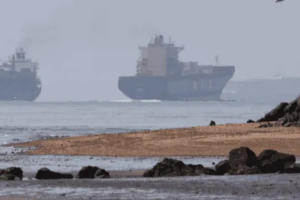
The northwest B.C. strategy includes liquefied natural gas (LNG) exports, like Ksi Lisims LNG. Exporting LNG means building pipelines across the region, like the 670-kilometre Coastal GasLink pipeline, completed in 2024. Photo: Matt Simmons / The Narwhal
What are we conserving?
The prime minister’s announcement referenced the creation of a “conservation area the size of Greece.” Greece is about 130,000 square kilometres. Northwest B.C., depending on how you define it, is roughly twice the size. So is half the region slated for protection? Not exactly.
Carney’s office declined an interview request and referred questions to the Privy Council Office, a non-partisan body that advises the prime minister. Pierre Cuguen, a spokesperson with the office, was vague on details but said the strategy will “focus on development of mining, energy and trade infrastructure” while also setting aside conservation areas to “help Canada meet its goal to protect 30 per cent of land and marine areas by 2030.”
Canada has committed to conserving “30 per cent of land and marine areas by 2030.” That goal is intended, in part, to protect fish and wildlife populations. Photo: Matt Simmons / The Narwhal
Cuguen did not specify areas that would be included, explaining plans will be developed in consultation with “stakeholders and Indigenous Rights-holders” and said “details on the approach are not yet confirmed.”
However, several Indigenous Protected and Conserved Areas, or IPCAs, are already on the table in northern B.C. Taken together, four conservation plans proposed or declared by the Kaska Dena, Tahltan, Gitanyow Hereditary Chiefs and Taku River Tlingit amount to an area more than half the size of the Mediterranean country home to spanakopita.
The Kaska Dena IPCA, which has been in the works since at least 2019, called Dene K’éh Kusān, would protect 40,000 square kilometres of lands and waters. (It’s more on the northeast side of B.C., but technically the entire province is west of Ottawa, so we can let that slide.) The Tahltan plan includes protecting 10,000 square kilometres in three separate areas, including one known as the Sacred Headwaters, where Indigenous leaders and allies fought a protracted battle two decades ago to prevent Shell from drilling for coalbed methane and Fortune Minerals from developing an open-pit coal mine at the headwaters of the Skeena, Nass and Stikine rivers.
Meanwhile, Gitanyow declared a 540-square-kilometre-area protected in 2021, and has since proposed protection for another 88-square-kilometre area. Taku River Tlingit similarly proclaimed protection of the T’akú Tlatsini in 2023, conserving 60 per cent of the nation’s namesake watershed, or around 18,000 square kilometres, which has been heavily impacted by historic and modern mining activities.
Kechika River runs through Dene K’éh Kusān, a 40,000-square-kilometre area proposed for protection by the Kaska Dena. Photo: Taylor Roades / The Narwhal
In 2021, the Gitanyow announced immediate protection of 540 square kilometres of land and water in northwest B.C., including Strohn Creek. Photo: Ryan Dickie / The Narwhal
Notably, IPCAs do not necessarily preclude industrial development such as logging and mining.
All four nations are currently involved in an expedited land-use planning initiative announced by the B.C. government in June, which also includes the Nisga’a Nation. The planning is intended to map and assess “areas for conservation of biodiversity, including wild salmon, caribou, sheep and other sensitive species, and cultural values” while also clearly identifying “areas open to potential development, including mineral exploration.” The process is intended to be completed by June 2026.
Where’s the other half of Greece intended for conservation, you might ask? Good question. We don’t know.
What about mining?
While conservation appears to be part of the federal plan — and environmental advocates are cautiously hopeful this initiative will secure protections for delicate ecosystems in the region — it appears to be secondary to the government’s goals to rapidly expand and diversify the Canadian economy. This includes putting its weight (and financial subsidies) behind extractive industries like mining and fossil fuels.
The northwest is “home to the Golden Triangle, one of the world’s richest reserves of the minerals and metals that are essential for the energy transition as well as defence supply chains for Canada and our allies,” Cuguen told The Narwhal in an emailed statement.
The Golden Triangle refers to an area which has long been a hotbed of mining activity. Most of the mining here has been for gold, as its name suggests. Gold is currently fetching record prices on global markets. Its value has been steadily climbing for a few years and skyrocketed in 2025, passing US$4,100 per ounce in October. Gold is only minimally used in renewable energy technology such as solar panels and its role in the defence sector is primarily economic, with profits made from the precious metal used to offset the costs of extracting other minerals.
In northwest B.C., there are four operational mines (Red Chris, Brucejack, Dome Mountain and Blackwater) and another three (KSM, Eskay Creek and Galore) in various stages of securing approvals, permits or investment. The strategy announced by Carney’s government and referred to the Major Projects Office includes only one mine, the already-operating Red Chris mine on Tahltan territory.
Red Chris is a copper and gold mine currently owned by Newmont, an American gold mining corporation with headquarters in Colorado. Newmont is in the process of advancing plans to expand production and convert operations from open-pit mining to block-cave mining. This expansion is what the feds are interested in.
How is this connected to LNG?
You can’t talk about this “corridor” without talking about liquefied natural gas, or LNG. Because it’s not just mining on the government’s mind. At the Terrace, B.C., press conference, Carney championed the province’s success in getting its long-awaited LNG export sector off the ground.
“We’re home to the world’s fourth largest reserves of natural gas, and we have the potential to supply up to 100 million tonnes annually of new LNG exports to Asia,” he said.
In the same breath, the prime minister named the recently approved Ksi Lisims LNG processing and export facility. Ksi Lisims is owned by Texas-based Western LNG in partnership with the Nisga’a Lisims Government.
Getting the fossil fuel to overseas markets will require building hundreds of kilometres of pipelines, in part, through this “conservation corridor.” Once it arrives on the coast, it will need to be cooled down to -162 C before it can be loaded onto tankers in its liquid state.
In Kitimat, B.C., where liquefaction started this summer, some residents are reeling from the impacts of the operation. Flaring, which is when a plant burns off excess or waste gas, has been ongoing for more than a year now as the massive LNG Canada facility slowly gets up and running. The plant’s flare stack has lit up the night skies with a flame about as tall as London’s iconic Big Ben.
LNG Canada in Kitimat, B.C., is Canada’s first major liquefied natural gas export facility. It has been conducting flaring activities since September, 2024. Photos: Marty Clemens / The Narwhal
This process also requires a lot of energy, which is where the North Coast transmission line comes in.
The transmission line would involve installing around 800 kilometres of new high-voltage wires across the northwest, in three stages. The wires, which require clearing wide swaths through forests and bisecting agricultural lands, would connect to the existing grid.
“Infrastructure investments under this strategy also link clean electricity to Canada’s ability to export LNG,” Cuguen wrote, adding the feds will be discussing how much money to throw at the plan “to ensure the potential of the region is achieved.”
But there’s a problem. Even with the wildly expensive Site C dam, it’s unlikely that B.C. can produce enough power to electrify LNG projects already on the books, let alone all the other industrial and commercial projects vying for power.
Corridor? What corridor?
In the statement sent to The Narwhal, Cuguen noted the northwest represents “one of Canada’s gateways to global markets through the Pacific Ocean.”
“This corridor will fundamentally transform the lives of thousands of Canadians, position Canada as a global leader in critical minerals and drive prosperity across the country,” Cuguen wrote, without explaining how or when the federal government expects this to happen.
In other words, the “corridor” probably has nothing to do with conservation. If the federal government wants to export more raw goods and resources to countries overseas, decreasing reliance on the U.S., it needs to lock in pathways across B.C.
The Privy Council statement also acknowledged northwest B.C. is “home to vibrant communities in a spectacular environment rich with mountains, glaciers, watersheds and coastal ecosystems.”
The looming question is how this influx of development will impact communities and sensitive ecosystems. If it comes to fruition, the strategy will certainly transform the lives of thousands of Canadians, but it remains to be seen which ones — and in what way.