
Shafaq News
Heavy rains
and flash floods are bringing an old danger back to the surface across Iraq:
landmines and unexploded ordnance (UXO) long buried under soil that many
communities had come to treat as “safe.” From southern Kirkuk and the outskirts
of Tuz Khurmatu’s Amerli district in Saladin to the Iraqi-Iranian border belt
in Wasit, residents and officials say torrents have shifted terrain, stripped
away topsoil, and exposed explosive remnants linked both to the Iran-Iraq War
and to battles against ISIS.
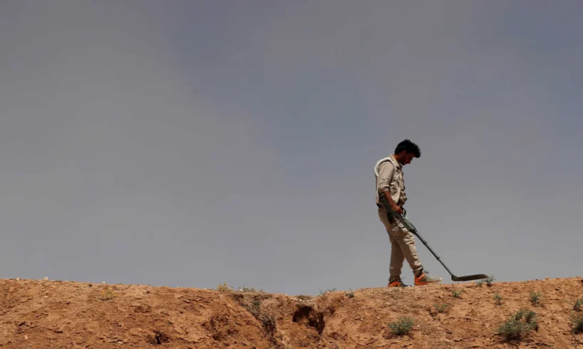
A source in
the Civil Defense Directorate told Shafaq News that the recent torrents
revealed explosive materials that had been hidden, adding that security forces
“stepped up measures to cordon off dangerous areas, secure them, and prevent
human incidents, with particular focus on the Iraqi-Iranian border in
Wasit—especially Badra and Jassan.
International
mine-action actors describe the landmine situation as a national, long-term
contamination challenge. UNMAS states that Iraq remains among the world’s most
explosive-ordnance-contaminated countries, with approximately 2,733 km² of
recorded contaminated areas—a scale that makes sudden environmental changes,
such as erosion and flooding, a significant risk multiplier.
When Water
Reshapes “Known” Ground
Floods do
not create mines, but they can change how mines behave in a landscape. Water
flow can erode banks and fields, displace soil layers, and carry debris that
conceals or relocates hazardous items. In practice, this means two things for
communities: Marked or familiar routes may no longer be reliable after the land
shifts, and objects that were stable while buried can become unstable when
exposed, raising the chance of accidental detonation through minor contact,
farming tools, or vehicle movement.
In southern
Kirkuk, resident Mohammad Khaled described that sudden uncertainty in stark
terms: “The land changed after the torrents, and we no longer know where the
dangerous areas are. People started avoiding passing through for fear of
explosions.”
In Saladin,
farmer Abbas Ali—from the outskirts of Amerli—pushed back against the idea that
the threat is limited to areas once held by ISIS. “The danger also includes areas that were contact
lines or old military sites. The torrents changed the features of the land and
increased the likelihood of explosive materials appearing.”
Along the
Iraqi-Iranian border, Jamil al-Badri, a notable from the Badra-Jassan area in
Wasit, said the anxiety runs even deeper because the geography itself is
layered with old frontlines. These lands, according to him, witnessed battles
and old military buildups during the Iran-Iraq War. He told Shafaq News that
this had left thousands of mines and unexploded ordnance. “Some residents
noticed soil erosion near shepherd and farmer routes, which increases the risk
of mines appearing.”
Read more: Iraq’s mines battles take their toll
Why This Is
Not Just A “Legacy” Issue
Iraq’s
contamination is a cumulative result of decades: the Iran-Iraq War, the 1991
conflict and its aftermath, post-2003 violence, and the anti-ISIS
campaigns—plus the widespread use of improvised explosive devices in certain
periods and areas.
The ICRC has
warned that landmines and explosive remnants continue to cast a long shadow
over recovery, citing large-scale contamination estimates and the way explosive
hazards constrain farming, reconstruction, and safe returns.
UNMAS and
UNICEF, focusing on children’s exposure, have also highlighted a sustained harm
pattern, reporting at least 314 children killed or injured by explosive
ordnance over the past five years, based on UN official reports.
For now, Iraq
still records casualties annually, reflecting how contamination persists even
outside headline cycles.
The key
point for flood-affected districts is that climate-driven shocks can reactivate
risk in places that were partially cleared or informally assumed safe—precisely
because terrain is not static.
“Reassessment”
Becomes The Frontline Policy
Former Civil
Defense officer and explosives expert Ahmed al-Jubouri framed the floods as a
turning point that requires immediate operational changes, not only warnings. “Materials
often remain stable as long as they stay buried,” al-Jubouri told Shafaq News.
“But soil movement and water make them exposed and unstable, increasing the
likelihood of explosion with the slightest contact.” He added that some areas
classified as partially cleared may return to posing a real danger after
climate changes.
Al-Jubouri
called for a fresh field survey, especially in Kirkuk, Saladin, and border
areas of Wasit, alongside intensified public awareness campaigns urging
residents not to approach or tamper with suspicious objects. His prescription
matches a core principle in international explosive-ordnance risk education: do
not touch, mark the location if possible from a safe distance, and report
through official channels—guidance reflected in mine-action risk education
materials and standards used globally.
The Operational
Bottlenecks
Security
sources told Shafaq News that demining teams face structural obstacles: missing
or inaccurate contamination maps, hard-to-reach rural areas and rough terrain,
limited resources, and uneven coordination between local and federal bodies.
Those
bottlenecks are not unique to Iraq, but Iraq’s scale makes them harder to
“patch” during emergencies. UNMAS emphasizes institutional sustainability and
standards-based coordination, including work linked to national mine action
standards discussions and the broader push to professionalize operations across
agencies and partners.
A Civil
Defense source in Wasit told Shafaq News that relevant authorities intensified
measures on the ground after the recent torrents, coordinating with demining
teams and international organizations to secure civilians and protect roads and
farmlands. The source stressed that risks remain a real threat to residents and
shepherds—especially after erosion changes the terrain.
International
agencies increasingly frame this as a recovery-and-development issue, not just
a security file. UNDP, for example, treats mine action as a prerequisite for
stabilization and service restoration in liberated and affected areas, linking
clearance and coordination to broader reconstruction needs.
Agriculture,
Returns, And The “Silent” Economic Cost
In Kirkuk
and Saladin, the immediate fear centers on daily movement—children walking to
school, farmers entering fields, shepherds using seasonal routes. But the
second-order effects can last longer: Agricultural slowdowns as farmers avoid
plowing or expanding cultivation in uncertain zones.
This is
where floods become strategically significant: they compress risk into a
shorter timeframe and expand the map of uncertainty, which can stall local
economies even without a single incident.
What “Smart
Response” Looks Like After Waters Recede
Local voices,
interviewed by Shafaq News, converge on one demand: faster surveying, clearer
warning signage, stronger public reporting channels, and sustained
official-international cooperation.
In practical
terms, the post-flood phase needs three tracks running in parallel:
-Rapid
reassessment and re-marking of priority zones (farms, schools, roads, grazing
paths).
-Community
reporting networks that treat residents as early-warning partners—without
pushing them toward risky “verification.”
-A funding-and-coordination
surge that prevents emergency cordons from becoming a permanent substitute for
clearance.
As Iraq
experiences more frequent climate extremes—heavy rains, sudden torrents,
seasonal erosion—the mine threat is increasingly a governance test: whether
state institutions and their partners can keep pace with a landscape that
changes faster than clearance plans.
Written
and edited by Shafaq News staff.