

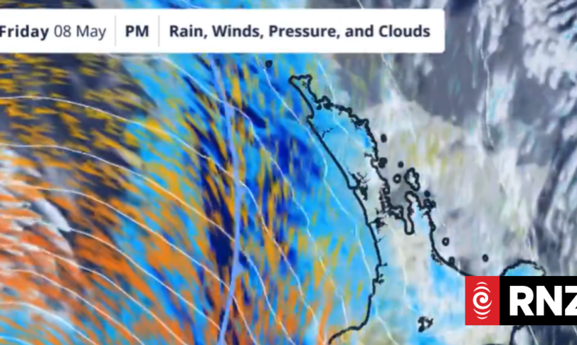
MetService radar showing heavy rain and strong winds hitting the South Island.
Photo: MetService
Flooding has closed two state highways as the South Island is battered by wild weather.
State Highway 6 is shut from Rai Valley to Havelock, which means there is no direct route between Blenheim and Nelson.
People can detour along State Highway 63 through the Wairau Valley to State Highway 6 at Kawatiri Junction.
State Highway 60 is also closed near Tākaka, near Pupu Valley Road with no detour available, meaning there is no connection between Tākaka and Collingwood.
Have weather photos you want to share? Send them to [email protected]
Several other South Island highways have been affected by the heavy rain, with flooding, slips and fallen trees on the West Coast.
They include State Highways 7 and 73, although they remain open.
On Friday afternoon police recovered a body from where a tractor went into the Otututu/Rough River near Ikamatua.
In the Buller district, emergency managers are asking freedom campers in Reefton to move away from the swollen Inangahua River.
People in the camping area on the Strand should move to higher ground because of the heavy rain.
Orange heavy rain warnings are in place for Westland until 6am Saturday, and the headwaters of the Canterbury lakes and rivers south of Arthur’s Pass until 4am Saturday.
The afternoon commute and Friday evening are looking wet and windy for many parts of the country as a second weather system crosses
Warnings and Watches remain in place
Along with that, thunderstorms in western areas this evening may bring bursts of intense winds to some areas pic.twitter.com/W1hGIqFVS1
— MetService NZ (@MetService) May 8, 2026
Gusts of up to 130km/h are forecast in exposed places in Christchurch and Canterbury Plains, Canterbury high country and Marlborough with orange strong wind warnings in place from Friday afternoon.
Wellington and Taranaki are also covered by an orange wind warning.
Powerco says 591 customers in Taranaki and 136 in Whanganui are experiencing weather-related power outages this evening.
Powerco says in Taranaki most outages are in Bell Block (101), Moturoa (207), and Marfell (272).
In Whanganui it says outages are on Turakina Valley Road (53), near Kai Iwi (25), near Parakino (25) and on Matarawa Valley Road (33).
Unsettled weather
MetService meteorologist Mmathapelo Makgabutlane told Midday Report parts of Nelson and Tasman had recorded up to 200 to 300mm of rain, mostly in elevated areas, over the last 24 hours to 36 hours
Makgabutlane said the unsettled weather would continue on Saturday, with showers and windy conditions forecast for many places.
“Into Sunday, the bulk of that weather has moved on but we could still see the odd shower and even maybe just a dusting of snow over those elevated parts of the South Island,” she said.
Jones Creek flooding in Westport.
Photo: Supplied / Brett Partel
MetService meteorologist David Miller said some South Island rain gauges had already recorded 100-130 millimetres in a 24-hour period.
“We’ve had some heavy rain in the ranges of the Tasman District and Westland on Thursday,” he said.
“Heavy rain is expected to continue in these areas right up until Friday evening.”
Warnings across the South Island
In the Tasman district’s north-west, heavy showers are expected to continue into Saturday morning, with thunderstorms possible.
The heaviest rain hitting the top of the South Island is expected to fall on Friday night, with rivers due to peak before midnight.
Tasman District Council said most would fall between 6pm and 8pm, with river peaks between 7pm and 11pm.
Up to 360mm has fallen in the ranges of Golden Bay, 100mm in Collingwood, 100mm on the Tākaka Hill and 94mm in the Tākaka township.
The Riuwaka, Wai iti, Wairoa/Waimea and Maitai Rivers were also expected to reach moderate flood flows.
Between 80 to 230mm had fallen in the Richmond & Bryant Ranges, with the potential for up to 140mm more in the Richmond Ranges and a further 80-120mm across the eastern ranges and hills behind Nelson.
In the Westland district and the headwaters of the Canterbury lakes and rivers, up to 220mm of rain is forecast about the ranges, at peak rates of up to 30mm/h.
Jones Creek flooding in Westport.
Photo: Supplied / Brett Partel
Severe gale northerlies and north-westerlies are forecast to gust up to 130km/h in exposed places in tChristchurch and Canterbury Plains, Canterbury High Country, Marlborough, Wellington and Taranaki.
Winds are expected to ease from the south early on Saturday morning.
Slips and flooding possible
Nelson City Council said there was surface flooding between Nelson and Renwick, and Maitai Valley Road was closed from Ralphine Way.
Network Tasman said a fallen tree had taken out powerlines feeding a section of Wakapuaka Road, Cable Bay, Teal Valley and Kokoroa, with 400 homes affected.
In the ranges of Golden Bay and Tākaka Hill, between 150 and 275mm of rain was recorded overnight, with the highest amounts in the Aorere River catchment.
The Tasman District Council said moderate flooding was expected in the Wai-iti, Wairoa and Motupiko Rivers, with people warned to expect water on the road between Korere and Kikiwa and State Highway 6 near Kohatu.
The council was expecting big waves in Golden and Tasman Bays, with wind-driven waves along the Abel Tasman coastline and shorelines of Ruby Bay through to D’urville Island.
Across in Nelson, between 120mm to 180mm but as much as 250mm was expected to fall in the Richmond Ranges, behind the Maitai River through to St Arnaud, on top of rain that fell on Thursday.
The Maitai River could also see a moderate flood, with the river full to its banks and flowing across low-lying paddocks and low points in roads.
The council said there was a possibility of land slips in places where the ground was sodden and there were strong winds, particularly in Pōhara, Abel Tasman, Richmond and Nelson.
Trees could also come down with severe northerly gales possible in exposed places and thunderstorms could cause localised surface flooding, Tasman said.
The Transport Agency was urging people to take extra care on State Highway 6 between Makarora in Otago and Haast on the West Coast because of flooding.
The NZTA said people should adjust their speed on slippery roads and avoid travelling through floodwater.
Sign up for Ngā Pitopito Kōrero, a daily newsletter curated by our editors and delivered straight to your inbox every weekday.