

It could last a couple of days too
The arctic blast will sweep across Europe
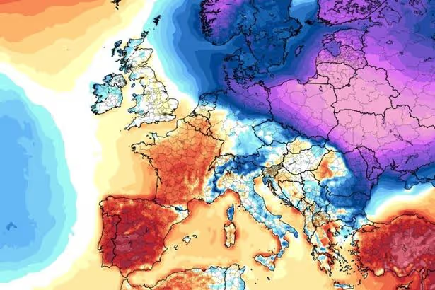
Leading weather experts are warning of an “intense” shot of arctic air that’s set to hurtle its way towards Europe over the coming days.
The Arctic blast will hit Eastern Europe first, with countries such as Poland and Ukraine set to feel its full force.
It will then push west, reaching Berlin before warmer temperatures replace it by the middle of next week.
Read More: Galway West By-Election date, candidates and schools with day off for vote
Read More: Met Éireann ‘large impacts’ weather warning as maps show exact areas hit by floods
Lead International Forecaster/Senior Meteorologist/International forecasting manager at AccuWeather, Jason Nicholls said: “A brief but intense shot of arctic air in the Baltics, Belarus, Poland & Ukraine this weekend into early next week. Some cold will reach as far west as #Berlin, Germany this weekend. The cold eases by midweek.”
Meanwhile, 13 counties in Ireland are currently under a Status Yellow rain warning as the country continues to feel the effects of Storm Chandra.
A Status Yellow Rain warning is in effect for Carlow, Dublin, Kilkenny, Louth, Wexford, Wicklow and Waterford.
Met Éireann spokesperson said: “Further heavy rain and showers falling on saturated ground, combined with high river levels, will lead to localised flooding, river flooding and difficult travel conditions.”
The warning is valid from 12:00 Friday 30/01/2026 to 00:00 Saturday 31/01/2026.
The UK Met Office has also issued a yellow rain warning for all six counties in Northern Ireland.
A Met Office spokesperson has warned of “spells of heavy rain leading to some transport disruption and flooding in places.”
Meanwhile, Met Eireann has released its latest forecast.
Friday
Rain in the south-east will spread up across most of Leinster and eastern parts of Munster this afternoon and evening, with some thundery downpours possible. Elsewhere, there’ll be variable cloud, some sunshine and scattered showers, some heavy and prolonged in east Ulster. With saturated ground conditions and high river levels, further localised flooding is possible. Highest temperatures of 7 to 10 degrees. Light to moderate south-easterly winds, but will continue fresh to strong at times near eastern and northern coasts.
Tonight
Outbreaks of rain will extend to most areas tonight, apart from the south-west where there’ll be clear spells and scattered showers. Clearer breaks will develop in other western areas overnight. With saturated ground conditions and high river levels, further localised flooding is possible. Lowest temperatures of 1 to 6 degrees, coldest under clear spells in the southwest, where frost is possible. Winds will be light to moderate and variable in direction, but fresh to strong near eastern and northern coasts.
Saturday
Tomorrow, Saturday, cloud and outbreaks of rain will continue to affect midland and eastern areas with sunnier breaks and a few showers elsewhere. The rain will become patchier as the day goes on and more bright or sunny intervals will develop. Highest temperatures of 7 to 11 degrees with light to moderate, variable winds.
For all the latest breaking news headlines today, visit our website home page. Galway Beo’s top stories and breaking news service on WhatsApp.
Click this link to receive breaking news and the latest headlines direct to your phone. We also treat our community members to special offers, promotions, and adverts from us and our partners.
If you don’t like our community, you can check out any time you like. If you’re curious, you can read our Privacy Notice.