

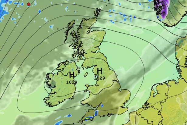
High-pressure systems set to dominate
Entirely clear skies in stable, Hgh Pressure conditions tomorrow (Tuesday) (Image: WXCHARTS)
If you feel a change on the way this morning, your instincts are right as the forecasters promise a break from the endless clouds and rain that have affected Munster and Ireland for weeks.
From today, we are in for a period of colder, brighter and dryer weather with tomorrow (Tuesday) promising to bring almost unbroken sunshine after what will be a frosty start for many. And through the week, while we will have some showers, it will be noticably brighter and dryer than it has been since the start of the year.
Into the weekend, Met Eireann as saying there will be ‘a lot of dry weather’ even if temperatures will remain on the cool side in fresh, bright and sometimes blustery conditions.
The full forecast for Munster this morning looks like:
TODAY – Monday 2nd March
It’ll be largely dry and bright to begin today with some sunny spells. However, it’ll become cloudier in western parts through the morning with scattered showers moving in, turning heavy at times. The showers will move further eastwards through the afternoon and evening, easing as they do and becoming isolated later. Highest temperatures of 8 to 11 degrees with south to southwest winds increasing moderate to fresh through the morning, stronger in coastal parts of the west, veering northwesterly and gradually easing mostly light or moderate later.
TONIGHT
Any remaining isolated showers will die away early on, to leave a mainly dry, clear night. Lowest temperatures of -1 to +3 degrees and with winds easing light and variable, some frost and ice will form. The odd patch of mist is possible.
TOMORROW – Tuesday 3rd March
Tomorrow, Tuesday, will be a dry, sunny day. After a cold frosty start, afternoon temperatures will rise to between 9 and 12 degrees in light to moderate variable, mainly east or southeasterly, breezes.
National Outlook
Overview: While weather fronts will break through from the Atlantic later this week, bringing rain, especially through Thursday, Ireland will be generally under the influence of high pressure for much of the week, which means we’ll have a good lot of dry weather overall. Temperatures will be around average to a little above for early Spring, with some pleasant spells of sunshine at times, though there’ll be frost on some of the nights.
Tuesday night: Dry with mostly clear skies at first on Tuesday night with frost becoming fairly widespread for a time. Low cloud will push up from the south overnight, along with mist and fog and possibly a few spots of light rain or drizzle. Lowest temperatures early in the night of 0 to 5 degrees, with the highest values along southern and eastern coasts, in mostly light to moderate southeasterly breezes.
Wednesday: There’ll be some bright or sunny spells on Wednesday, but in general there’s likely to be a good lot of cloud around. While there’ll be a lot of dry weather overall, there’ll be a little patchy drizzle, along with some mist and fog for a time too, mainly in the south and east, and a few isolated showers are likely to break out later on too in other areas. Highest temperatures of 10 to 14 degrees and becoming breezy through the day with southerly winds increasing moderate to fresh.
Wednesday night: A good lot of dry weather to begin the night with a mix of cloud and clear spells, though there’ll be a few scattered showers along with some areas of mist and fog. Cloud will thicken from the west overnight, with rain spreading eastwards to most areas. Lowest temperatures of 4 to 8 degrees, in moderate, occasionally fresh, southerly winds, veering westerly later in the night in western areas.
Thursday: Cloudy on Thursday morning with outbreaks of rain and drizzle continuing to spread eastwards to all areas. A clearance to mainly dry and brighter weather will push into western areas by the early afternoon, with the clearance slowly extending eastwards to most areas through the rest of the day. Highest temperatures of 8 to 11 degrees in moderate, occasionally fresh, winds becoming mostly north-westerly and easing later.
Thursday night: Mainly dry with clear spells. Cold with lowest temperatures of -2 to +2 degrees with some frost and icy patches.
Friday: It looks like Friday will be mostly dry with some spells of sunshine. Highest temperatures of 8 to 12 degrees.
Next weekend: It looks like high pressure will remain the most dominant influence on our weather through the weekend, so a lot of dry weather is expected overall, with some spells of sunshine, though some showers or rain are possible later in the weekend.
Want to see more of the biggest and breaking stories from Cork Beo? Making us your preferred source on Google means you’ll get more of our exclusives, top stories and must-read content straight away. To add Cork Beo as a preferred source, simply click here.