

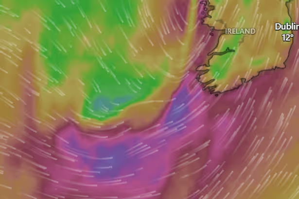
With perfectly bad timing, Storm Dave is bearing down on Ireland just in time for the long Easter weekend.
The whole country is facing into a Status Yellow weather warning, which kicks in at 1pm on Saturday – staying in place until 2am on Sunday. Met Éireann has warned Munster residents of strong and gusty winds tomorrow, with “high waves and high tides” giving rise to dangerous conditions in coastal areas.
Meanwhile, ESB has issued guidelines in case of an “electrical emergency,” anticipating the possibility of Bank Holiday power cuts.
Luckily for us, much of the impact of Storm Dave will head northwest across Saturday, with heavy rain winding down into scattered showers by Saturday evening. But in the meantime, the national forecaster has urged people to beware of spot flooding and the risk of debris, like fallen trees and branches.
And if you are travelling on Saturday, the advice is to do it early on in the day, before the heavy wind and rain strikes with the 2pm warning.
The weather alerts come as ESB issues advice to customers in the case of an electrical emergency caused by Storm Dave. Writing on X, ESB said: “Met Éireann has issued a wind warning for Saturday April 4th due to #StormDave Here is some advice on how to stay prepared. In case of electricity related emergencies call us on 1800 372 999.” You can see ESB’s guidance below:
Content cannot be displayed without consent
Weather expert Alan O’Reilly at Carlow Weather has better news for Sunday – though he warns that it’s likely to be a chilly one. He said: “The good news is Easter Sunday will see good spells with a nice sunrise for many. The bad news is that you will want the big coat for the egg hunt as the it will feel bitter in the windchill with cold air over Ireland. It will be breezy but not as strong on Saturday.”
You can see Met Éireann’s full forecast for Munster, updated at 4:30pm, below:
Today
A mix of cloud and sunny spells for the rest of today with scattered showers becoming isolated. A few may be heavy. Moderate, locally fresh, westerly winds will back southwest and ease this evening.
Tonight
Quickly becoming cloudy tonight, with outbreaks of rain and drizzle spreading northeastwards across the province overnight. Lowest temperatures of 3 to 6 degrees and coldest early in the night. Light southwest winds will back south to south-east and freshen in southwestern parts of Munster towards morning.
Tomorrow
Storm Dave will bring wet and very windy conditions on Saturday. South to southeast winds, veering southwesterly, will increase very strong and gusty through the day. The strong onshore winds coinciding with high waves and high tides will give risk of wave overtopping and coastal flooding. Cloudy with outbreaks of rain and drizzle becoming isolated by midday. A band of heavier and more persistent rain will spread from the west in the afternoon with spot flooding possible. A clearance to scattered showers will follow later, with winds veering westerly in most parts. Highest temperatures of 10 to 13 degrees.
National Outlook
Overview: Continuing unsettled for the remainder of the Easter weekend and into next week. It will be breezy or windy, and also wet, at times. However, there will also be some brighter weather, especially on Sunday.Saturday night: Starting off wet and windy. However, the rain will soon clear, followed by clear spells and scattered showers, some of which may fall as hail or sleet on higher ground. A cold night with lowest temperatures of 0 to 4 degrees, with winds becoming westerly and easing overnight.Sunday (Easter): A bright and breezy day with sunny spells and scattered showers. Some of the showers may be of hail or sleet early in the day on higher ground. The showers will become more isolated towards evening. Feeling cool with highest temperatures of just 7 to 10 degrees, with moderate to fresh westerly winds easing in the evening.Sunday night: A dry night for most. While it will start off mostly clear, cloud will build from the west through the night. Outbreaks of rain and drizzle may encroach on some Atlantic coastal areas towards morning. Lowest temperatures of 0 to 4 degrees, but increasing through the night with the arrival of the cloud. Light southerly winds will freshen through the night.Monday: A windy day, it will be generally dull with patchy outbreaks of light rain, drizzle and mist. Some brighter spells may develop later in the day. Feeling milder with highest temperatures of 10 to 14 degrees, with fresh to strong southerly winds.Tuesday: Current indications for a wet and breezy day with widespread outbreaks of rain. Highest temperatures of 12 to 15 degrees, with moderate to fresh southeasterly winds easing towards evening.Further outlook: Continuing unsettled for the remainder of the week as the mobile Atlantic regime continues.