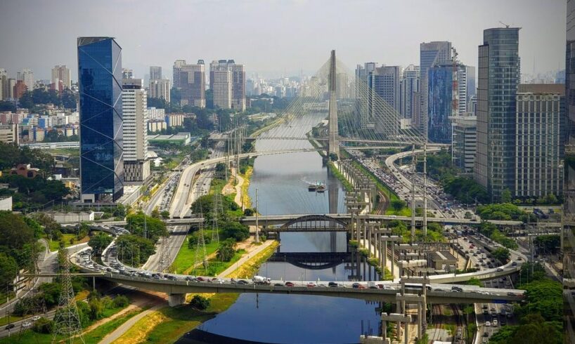
São Paulo live — Jesuit mission 1554, coffee boom, Italian immigrants, concrete megacity
São Paulo was founded on January 25, 1554, by Jesuit missionaries (Manuel da Nóbrega and José de Anchieta) on a plateau 70km inland from the Atlantic coast — chosen for its mild climate and defensive position. For three centuries it remained a minor town. The coffee boom (1880-1930) transformed it: São Paulo became the processing and trading hub for Brazil’s coffee exports, generating wealth that funded industrialization. Between 1880 and 1930, 2.5 million immigrants arrived in São Paulo state — predominantly Italian (1M+), Spanish, Japanese (São Paulo has the largest Japanese community outside Japan: 1.5M), Lebanese, German, and Syrian. This immigrant diversity shaped the city’s culture, cuisine, and architecture irreversibly. Today São Paulo’s metro of 22 million generates approximately 40% of Brazil’s entire GDP — more than the rest of the country combined. It is simultaneously the financial capital, industrial capital, fashion capital, restaurant capital, and cultural capital of South America. It is not beautiful in the conventional sense. It is overwhelming, complex, and essential.
22MMetro inhabitants
40%Brazil’s GDP
12,000+Skyscrapers
1.5MJapanese community
What the cameras show
🏙️
São Paulo skyline — concrete forest, Avenida Paulista, 12,000+ towers
YouTube Live · City skyline · Av. Paulista · Concrete · 24/7
The YouTube live stream captures São Paulo’s defining visual reality: an unbroken forest of concrete and glass towers stretching to every horizon. With 12,000+ skyscrapers, São Paulo has more high-rise buildings than New York. The city occupies 1,521 sq km of the Serra do Mar plateau — flat enough to urbanize continuously in every direction. Avenida Paulista (2.8km, 35-lane boulevard) is the financial spine: banks, multinational headquarters, MASP (Museu de Arte de São Paulo, Oscar Niemeyer-inspired Lina Bo Bardi, 1968), cultural centers, protests. The camera shows the city’s day-night cycle, tropical rain storms (frequent year-round), helicopter traffic (São Paulo has one of the world’s busiest helicopter fleets — wealthy residents avoid ground traffic), and the perpetual construction of a city that never stops building.
Watch live →
✈️
Guarulhos International Airport — Brazil’s main hub, 40M passengers
Worldcams.tv · GRU airport · 40M passengers · LATAM · Embraer hub
Guarulhos International Airport (GRU, officially Aeroporto Internacional de São Paulo/Guarulhos — Governador André Franco Montoro) is Brazil’s busiest airport and South America’s most connected hub — 40+ million passengers annually, 120+ destinations worldwide, LATAM Airlines’ primary base. The webcam shows the airport’s constant air traffic: departures to Europe (Lisbon 10h, London 12h, Paris 12h), North America (Miami 8h, New York 10h), and the entire South American network. Embraer (the world’s 3rd largest commercial aircraft manufacturer, headquartered in São José dos Campos 100km from São Paulo) supplies regional jets to airlines globally — visible in the airport traffic. The airport is a measure of São Paulo’s economic weight: its air connectivity directly reflects the city’s position as the financial capital of Latin America.
Watch live →
☕
1880-1930: The coffee economy builds a megacity — and brings 2.5 million immigrants
By 1880, Brazil produced 70% of the world’s coffee, and São Paulo state was its center. The profits funded railways, processing plants, and urban infrastructure. The fazendeiros (coffee planters) needed labor: the Brazilian government actively recruited European immigrants after abolishing slavery (1888). Italians came first and in largest numbers — entire villages from Veneto, Calabria, and Sicily relocated. They built the neighborhoods (Bixiga/Bela Vista became “Little Italy”), introduced pizza (São Paulo consumes more pizza per capita than any city outside Naples — 1 million pizzas daily), and named streets across the city. The coffee boom ended with the 1929 crash (US market collapsed, coffee prices fell 70%). But the industrial infrastructure built on coffee profits survived — São Paulo pivoted to manufacturing, becoming Latin America’s industrial capital by 1950.
São Paulo beyond the cameras
The restaurant capital of South America: São Paulo has 50,000+ restaurants — more per capita than New York. Japanese restaurants (second-best outside Japan, per international chefs), Italian trattorias in Bixiga unchanged since 1930, Lebanese and Syrian mezze in Higienópolis, contemporary Brazilian cuisine in Vila Madalena, churrascarias (rodízio beef) everywhere. The São Paulo restaurant scene is the city’s primary cultural achievement and social equalizer — eating well is a democratic value in a deeply unequal city.
Paulistano Carnival — deliberately not Rio: São Paulo’s Carnival (Grupo Especial, 14 samba schools, Sambódromo do Anhembi) is technically superior to Rio in musical complexity and costume design — São Paulo samba schools have won more national championships. It is also completely different in atmosphere: less tourist-oriented, more competitive, attended primarily by Paulistanos. The city takes perverse pride in doing Carnival better than Rio while receiving none of the global credit.
The two webcams show São Paulo without romantic filter: the skyline is an honest portrait of a city built for production, not aesthetics — 12,000 towers, no visible plan, extraordinary energy. The airport shows the city’s global connectivity, its position as Latin America’s financial nerve center, its permanent state of motion. São Paulo does not invite admiration the way Rio does. It commands respect — for its scale, its diversity, its economic weight, and its inexhaustible drive.
When to watch
Tropical rainstorms (October-March, 4-7pm): São Paulo’s afternoon storms are spectacular — dark clouds build rapidly over the concrete, lightning illuminates the skyline, 80mm of rain falls in 30 minutes. The city floods (Tiête and Pinheiros rivers overflow regularly). The YouTube feed shows the storm building and the city disappearing into rain and mist. Gone in 45 minutes; the city resumes.
Guarulhos at dawn (4-7am): The airport’s first wave of international arrivals — overnight flights from Europe and North America landing as São Paulo wakes. The tarmac is busy with wide-body aircraft (B777, A350, B787) taxiing in early light. The airport camera shows South America’s connections to the world condensed into two hours of morning activity.
Avenida Paulista on Sundays: Every Sunday, Avenida Paulista closes to traffic and becomes a pedestrian promenade — cyclists, runners, street performers, food vendors, political activists, families. The YouTube feed shows São Paulo’s most visible democratic moment: the financial capital transformed into a public park for one day weekly.
Getting there: Guarulhos International (GRU, 40km northeast) — Airport Bus Service to Tietê bus terminal 50 min (R$60); taxis R$120-180; Uber more reliable. Congonhas Airport (CGH, 8km south, domestic) serves the Rio-São Paulo air shuttle (40+ daily flights). The São Paulo Metro (5 lines) is efficient but limited — covers the center and Avenida Paulista (Consolação/Brigadeiro stations, Line 2). Surface traffic is severe: average São Paulo commuter spends 2h30 daily in traffic. By air: Rio de Janeiro 1h, Buenos Aires 2h30, Lima 4h, Miami 8h, Lisbon 10h, Paris 12h.
🌍
All webcams — worldwide cities, mountains & coasts
Live cameras across France, Europe and beyond — Sports Infos.
All webcams →