

Weather experts have highlighted the arrival date and time
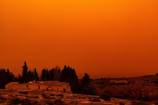
Sky with reddish tones due to the arrival of Saharan dust on 14 March, 2022 in Navares, Caravaca de la Cruz, Murcia, Spain.
Blood rain is set to fall across Ireland this weekend – potentially ruining any plans you might have for washing your car or cleaning your windows.
Blood rain is a meteorological phenomenon where rainfall takes on a reddish or orange tint. It occurs when fine, iron-rich particles from the Sahara Desert are lifted into the atmosphere and carried enormous distances by winds, before mixing with precipitation.
The Saharan particles are expected to arrive in Ireland towards the end of the week – with Sunday looking set to be the worst affected day. Alan O’Reilly from Carlow Weather has warned that rainfall and hail showers forecast to hit the country over the weekend could bring those particles down to surface level.
Posting footage of the particles moving northwards over the nation, he said: “Saharan dust forecast shows the dust is forecast to reach Ireland towards end of week, and some showers could bring some of that dust down to the surface.”
Meanwhile, much of Ireland is enjoying a beautiful sunny beginning to Tuesday as we look ahead to damper conditions developing later in the week.
The capital will experience temperatures rising to 17C today in what ought to be a largely mild day. Some periods of rain are anticipated at intervals as further cloud cover moves in, reports Dublin Live. This evening will stay mainly dry with reasonably mild conditions as temperatures hit 10C. Mist and fog will form in some areas.
Saharan dust is forecast to reach Ireland at the weekend
Met Éireann stated: “Today will start mostly dry with sunny spells. Cloudier conditions will spread from the west with some showery outbreaks of rain possible. Mild with highest temperatures of 15 to 17 degrees in moderate, southeast winds, easing mostly light southerly later.
“Tonight will be mostly dry but cloudy overall, with limited clear spells. Areas of mist and fog will form in light variable breezes. Lowest temperatures of 7 to 10 degrees.”
The milder weather will persist on Wednesday. The day will be predominantly dry though cloudy, with decent sunny intervals.
While there may be sporadic drizzle, this won’t properly set in until evening. Wednesday night will be slightly cooler with temperatures hovering around 7C.
For all the latest breaking news headlines today, visit our website home page.
Met Éireann added: “Tomorrow, Wednesday will be dry for most with a lot of cloud and some sunny spells. Cloud will build from the west through the afternoon and evening. Highest temperatures of 15 to 17 degrees, in light west or southwesterly breezes.
“Outbreaks of rain and drizzle in the west will move eastwards, with clear spells and scattered showers following on Wednesday night. Turning cooler behind the rain with lowest temperatures of 3 to 7 degrees in moderate westerly winds.” Conditions are set to worsen by Thursday, with heavy downpours potentially turning thunderous. There’s also a chance of hail. Temperatures will drop. As we head towards the weekend, conditions will become increasingly blustery and unsettled, bringing widespread rain and overnight frost.
Thursday
Any lingering showers in the east will clear early on. Otherwise, anticipate sunny spells and scattered showers, some of which may turn heavy and possibly thundery with a risk of hail, before gradually easing off into the evening. It’ll be cooler than recent days with top temperatures of 8 to 11 degrees in fresh and gusty westerly winds, which will calm down later.
Friday
Prepare for a blustery and windswept day with fresh to strong and gusty southerly winds. Rain in the west will become heavy and prolonged at times, before moving eastwards as the day goes on. Highest temperatures will range from 10 to 13 degrees in moderate to fresh southwesterly winds.
Weekend
Current forecasts suggest further rain and hail showers throughout the weekend, although some drier and brighter intervals are also expected. Temperatures will fall slightly with overnight frost likely.
Join Galway Beo’s top stories and breaking news service on WhatsApp.
Click this link to receive breaking news and the latest headlines direct to your phone.
We also treat our community members to special offers, promotions, and adverts from us and our partners.
If you don’t like our community, you can check out any time you like.
If you’re curious, you can read our Privacy Notice.